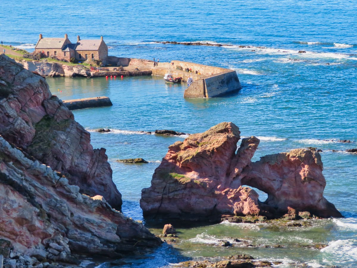
Cove Harbour
The Southern Upland Way runs for 212 miles between the west and east coasts of southern Scotland. This section on the east coast is located a short distance from the coastal town of Dunbar.
The route starts at Cove Harbour and continues along gorse-covered cliffs before finishing at Pease Bay which is best known for its family-friendly caravan park. Discover this beautiful stretch of Borders coastline in this guide which includes an overview and useful visiting tips.
🠇 Head to the bottom of the page for essential details on each attraction featured here, including addresses, opening hours, and entry prices 🠇
Cove Harbour
The Southern Upland Way runs for 212 miles between the east and west coasts of southern Scotland, from Portpatrick in the southwest to Cockburnspath in the southeast. While much of the route is unknown to casual walkers, many hiking enthusiasts complete the trail in its entirety each year, starting on one side of the country and coming back each weekend to finish off another section.
Both the east and west ends of the Southern Upland Way feature some truly remarkable landscapes, but this second-to-last section on the east coast is definitely worth a visit thanks to the spectacular coastal views it offers. This part of the Berwickshire coastline offers a lot of variety for seasoned walkers, yet it’s gentle enough that families can enjoy a leisurely stroll along the rugged clifftops and rolling hills.
The Highlights
1: Cove Harbour is one of the nicest, most secluded sunbathing spots I’ve found in Scotland and is the very definition of a ‘hidden gem’.
2: The harbour walls project into the sea, and as you can walk along them, they make a great spot to go wildlife watching. The bay is frequently visited by dolphins and seals, so taking a pair of binoculars (link to binocular reviews) is recommended.
3: From Cove, visitors can go on a lovely walk along the clifftops in a part of the country that sees few tourists.
Visiting Tips
1: There aren’t any facilities at Cove Harbour, so if you want food and drink, you’ll have to take your own. A lightweight backpack (link to backpack reviews) will come in very handy for that reason.
2: This section of the Southern Upland Way is ok for mountain biking but I think it’s best enjoyed by walking. There’s a car park at Cove if you decide to go there by car.
3: Check out the official Southern Upland Way website for detailed route maps.
Tourist Information
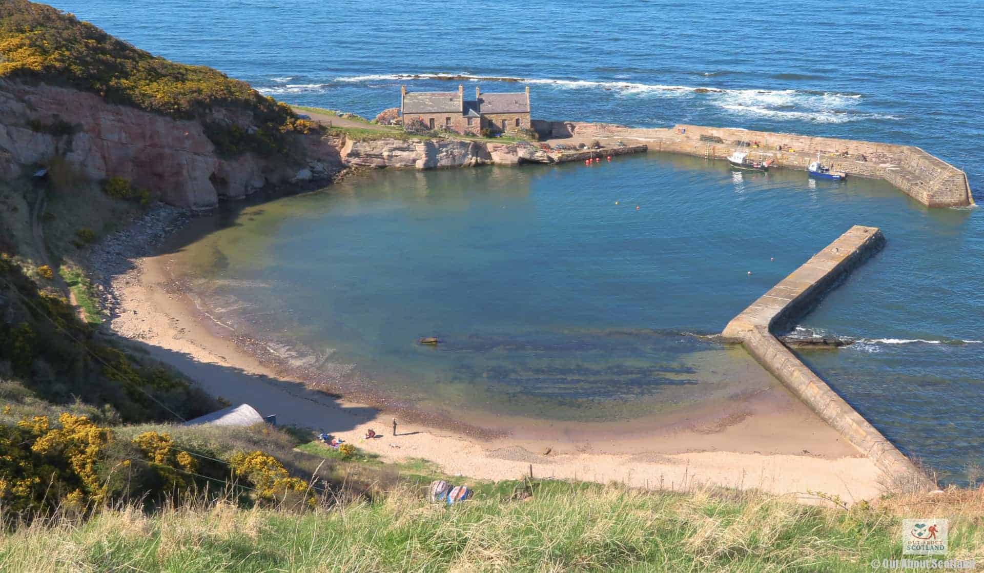
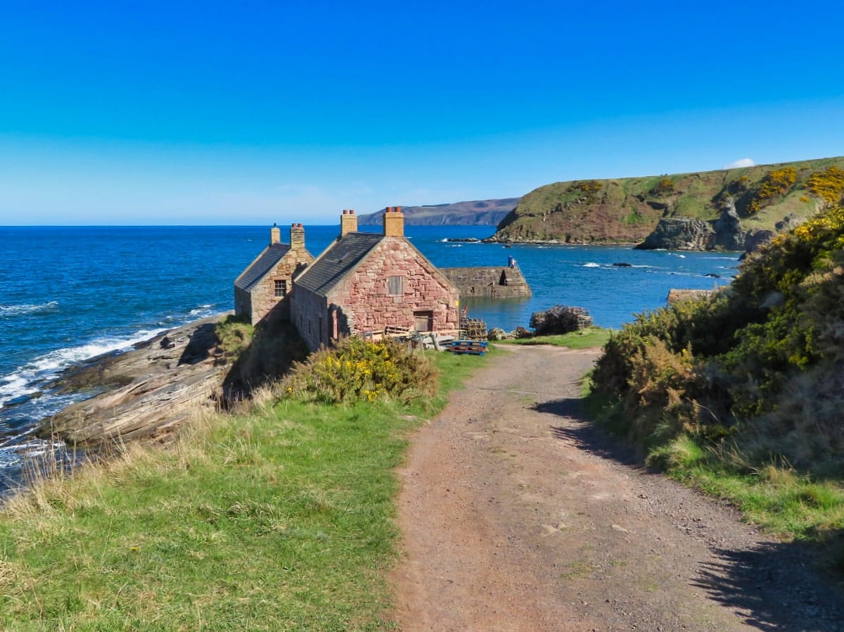
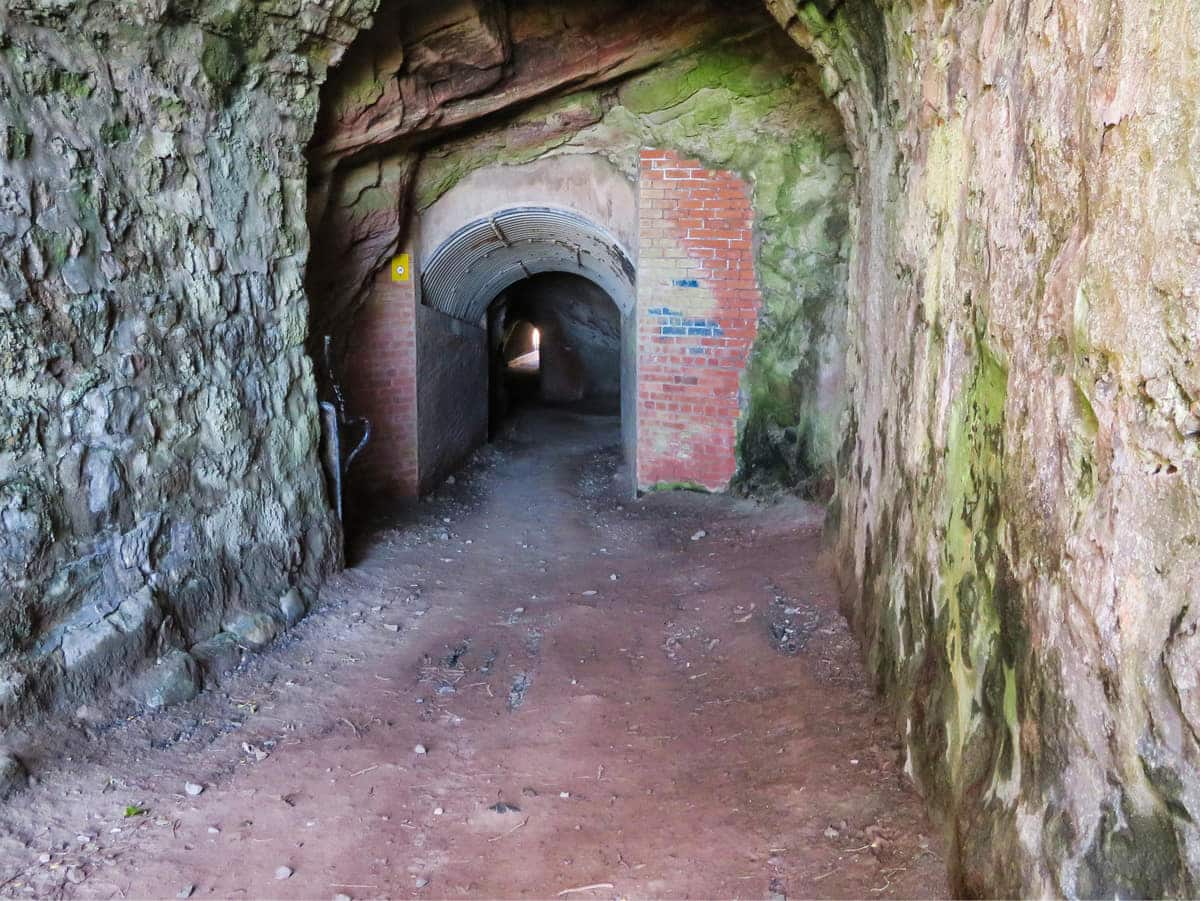
Starting at the car park in Cove, you’ll see the signs that point in the direction of Pease Bay, but there’s also an alternative route down to Cove Harbour. To get there, you’ll have to walk through a tunnel that’s bored through the cliffs, after which you’ll find yourself on a small sand beach set behind a red sandstone harbour.
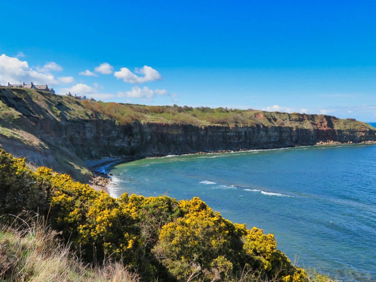
Sandstone cliff faces surround the cove in a wide arc, and with the harbour walls protecting the beach from the North Sea, it feels a wee bit like being on a Mediterranean coastline if you visit on a summer’s day. It’s certainly worth walking around the harbour, after which you can return to the clifftop path to continue your journey to Pease Bay.
The route between Cove and Pease Bay follows the coastline quite closely, and as it’s elevated on top of the cliffs you’ll have great views in all directions. Along the footpath you’ll find gently rolling farmland to one side and the crashing waves of the North Sea to the other, while the entire route is surrounded by the vanilla scent of flowering gorse bushes.
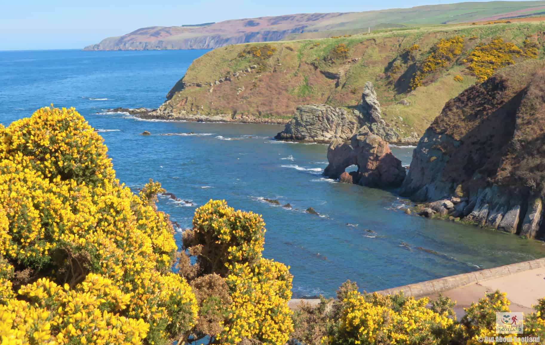
There are a few quiet bays and beaches all along this section of the trail, but they’re located at the bottom of some very steep slopes so it’s best to stick to the designated walkway. I guess you could head down to one of these bays if you wanted to make the perilous descent, and you’d probably find you’d have the beach entirely to yourself, but you’d be doing so at your own risk. Definitely don’t try it if you have children with you.
After an hour of walking, you’ll reach the headland of Pease Bay with the wide-open, golden beach stretching away in front of you, so if you want to get down to the seafront just follow the path ahead that leads down towards the caravan park.
The more adventurous who intend to finish the next part of the Southern Upland Way can continue past the caravan park onto the main road which has signs pointing towards the next section. Meanwhile, those who’ve simply gone to Pease Bay to admire the views can now turn around and take a leisurely stroll back to Cove. In total, expect to spend two to three hours exploring Cove and Pease Bay, but if you’re just walking along the clifftops, you could complete it in just over an hour.
Things to Do
Cove Harbour: Travel back in time by visiting the 1828-built Cove Harbour, which is still in use by fishing boats. There’s a stretch of golden sand for relaxing beach days, as well as a path at the top of the cliffs that offers stunning views of the surrounding coastline.
Pease Bay: Discover the beauty of this part of Scotland by visiting Pease Bay, a lovely sandy beach a 1/2 mile south of Cove. The beach offers a picturesque setting for a leisurely stroll where you can watch the waves roll in before heading inland to join the Southern Upland Way long-distance walking trail.
Cove Coastal Path Hike: Experience the scenery of the East Lothian coastline by hiking the Cove Coastal Path. This hiking route offers panoramic views of the North Sea and if you’re lucky, you might even spot seals and dolphins offshore.
Visit St. Abbs Head: Just a short drive from Cove, the St. Abbs Head National Nature Reserve is a haven for nature lovers. The rugged clifftop paths offer spectacular views and the area is renowned for being home to thousands of seabirds.
Scuba Diving: For the adventurous, a diving trip in the waters around Cove is a must. The sea in this part of the East Lothian and the Borders is teeming with marine life, offering an unforgettable underwater experience.
Things to Do Nearby
Woodhall Dean Wildlife Reserve. Dunbar EH42 1SJ. 14-minute drive.
Nature reserve on the edge of the Lammermuir Hills. This reserve is home to sessile oak trees (a once-abundant tree that is now dwindling in numbers) and it is highly regarded for the carpets of woodland wildflowers that bloom in spring.
St. Abbs Head. Eyemouth TD14 5QG. 28-minute drive.
National nature reserve in a spectacular clifftop setting that is famed for its seabird colonies. There are a multitude of footpaths that offer walks throughout the reserve and there is a small loch slightly inland that is a haven for ducks, swans and other wildlife.
Thorntonloch Beach. Dunbar EH42 1QS. 7-minute drive.
A lengthy section of golden sand south of Torness power station. The shallow beach enjoys some of the best waves on the East Lothian coastline making it a popular spot for bodyboarders.
Whitesands Bay. Dunbar EH42 1QP 12-minute drive.
a well-liked bay a few miles southeast of Dunbar, with Whitesands Beach’s golden sands and the Whitesand Nature Reserve’s lush vegetation as its backdrops.
The reserve is alive with wildlife and visitors are almost guaranteed to see owls, wading birds, roe deer, red foxes and many more species. The beach meanwhile is relatively quiet and allows access to superb coastal footpaths in both directions.
Fast Castle. Eyemouth TD14 5TY. 16-minute drive.
A ruined castle situated on a rocky headland a few miles north of St. Abbs Head. The castle isn’t much more than a collection of ramshackle walls but it is a favourite spot for wildlife watchers thanks to the seal colonies that can be seen on the rocks below.
Frequently Asked Questions
What is the history of Cove Harbour?
The harbour was first established during the 17th century and was primarily used for fishing, with its local residents known for their expertise in catching herring. The harbour was also a loading point for exporting the locally quarried Cove sandstone. This stone was used to build many of Edinburgh’s iconic buildings.
The harbour’s history was marked by numerous events, including 1791, when British naval officers forcibly recruited men from the village into service, resulting in the deaths of several villagers. At the top of the cliff, there is a cairn commemorating this occasion.
Another tragedy struck Cove Harbour in the middle of the 19th century when a storm killed 11 fishermen. There is a memorial in the village to honor this event, which had a significant impact on the community.
The harbour is still operational and continues to be a focal point for the village. It’s also a popular tourist destination, offering breathtaking views of the North Sea and the surrounding countryside.
Who owns Cove Harbour?
Ben Tindall, an architect, and Cove Harbour Conservation Ltd. are the owners of Cove Harbour.
Is Pease Bay a private beach?
Pease Bay is a public beach. It’s located 9 miles south of Dunbar, off the A1 at Cocksburnspath.
What visitor facilities are there at Cove Harbour?
There are no visitor facilities at Cove Harbour, but there is a car park in the village.