Bealach na Ba
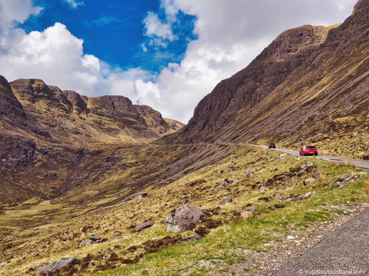
The Bealach na Ba is a twisting mountain pass on the Applecross Peninsula in Wester Ross that’s undeniably the most famous section of the North Coast 500 Highland touring route. This single-track road rises over 2,000 feet (0.61 km) at its highest point and is famous for being one of the most scenic drives in the world, as well as one of the most dangerous due to its tight hairpin bends.
🠇 Head to the bottom of the page for essential details on each attraction featured here, including addresses, opening hours, and entry prices 🠇
Bealach na Ba
The Bealach na Bà is a historic and iconic pass in the Highlands. Known for its steep gradient and tight hairpin bends, it’s an exhilarating drive for adventurous motorists and a must-do challenge for road cyclists. Offering stunning views of the Applecross Peninsula and the Isle of Skye, it’s considered one of the most scenic roads in Britain.
To be honest, I wouldn’t normally include a road in this website. After all, how can a boring road be classed as a tourist attraction? Normally it wouldn’t, but then the Bealach na Ba is no ordinary road. Imagine an alpine pass with tight, hairpin bends that twists its way through gobsmacking Highland mountains, and you’re on the right track, but still a mile from what it actually looks like in real life.
The Bealach na Ba (or ‘Pass of the Cattle’ in Gaelic) is located in the southern half of the Applecross Peninsula, more or less directly east of the Isle of Raasay and north of the Kyle of Lochalsh.
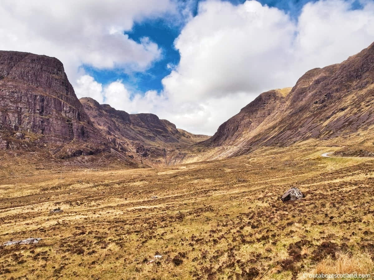
This area of Scotland is incredibly beautiful, with vast mountain ridges flanked by dramatic corries and sweeping plains of moorland punctuated by countless lochs and lochans. It’s wild, desolate, dramatic, and utterly beautiful.
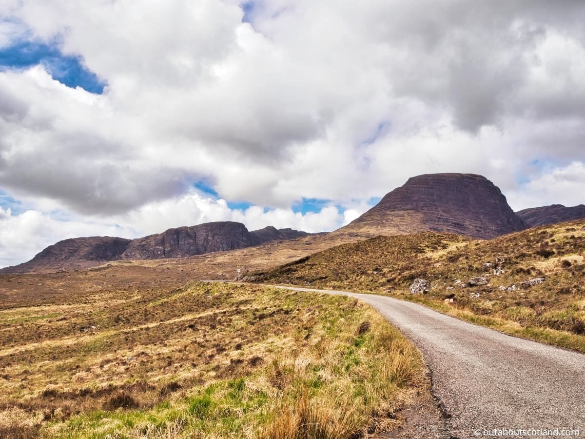
The Bealach na Ba threads its way through this landscape for 45 miles from the junction of the A896 at the point where the River Kishorn joins Loch Kishorn to the small village of Applecross, which overlooks Applecross Bay on the southwest corner of the peninsula. The road starts off gently enough, with a shallow gradient that can leave you feeling a tad underwhelmed.
However, everything changes when you round the first corner and see the line of tarmac losing itself amongst the towering mountains that loom ahead. Straining your eyes, you can just about see the famous hairpin turns that lead to the summit.
Those twisting – sometimes 180° – bends continue steadily uphill to the highest point of the pass which sits a remarkable 2,053 feet (0.63 km) above sea level, before winding down the slightly less exhilarating western side of the pass which finishes at the attractive Applecross Bay.
It’s a genuinely exhilarating journey, with some gradients approaching 20% (making the Bealach na Ba the steepest road in Britain) and views that rival any alpine pass in Europe.
As far as what it’s like to drive, the road is narrow but in good condition, with few potholes, and just wide enough on some sections for cars to pass each other. There are also crash barriers lining the upper half leading to the summit with a few vertigo-inducing drops, so if you haven’t got a head for heights, I suggest not looking over the side.
Before moving on, in the interest of safety, I have to mention that this road is absolutely not suitable for inexperienced drivers, motorhomes, or cars with caravans. If you fall into either of those categories, you should take the alternative signposted route that circles the peninsula up its eastern side to Shieldaig, along its northern edge, and then back down to Applecross.
In fact, local breakdown services suggest you don’t attempt the Bealach na Ba in anything larger than a VW camper. Although there are lots of passing spaces it only takes one accident to completely block the pass for other road users – something to be doubly aware of in winter when the steep verges on the roadside are covered with snow.
Another point to note about this road is the fact that it’s quite popular with cyclists (how they manage it I have no idea) so drivers will inevitably get stuck behind them, and once you’re halfway up there are safety barriers and steep verges meaning it’s very difficult to pull in. That being said, the Bealach na Ba is one of the most scenic roads in Scotland and is a must-do for anyone thinking of driving the NC500.
The Highlights
1: The viewpoint from the first car park that overlooks the steepest section of the Bealach na Ba is stunning and is one of those views you’ll never forget.
2: The summit car park is a good place to stop and explore the surrounding landscape. There are lots of great walks in the area but it’s very remote, boggy, and tough going. When I visited, I took an Ordnance Survey map, which was invaluable.
3: This is (in my opinion) the most scenic drive in Scotland. If you’re thinking about driving part of the NC500, the Applecross Peninsula is a must.
Visiting Tips
1: Expect to get stuck behind queues of traffic in summer, especially at the weekend and when the schools are on holiday. I last visited midweek in April and I had the majority of the road to myself which was an unforgettable experience. That’s something to bear in mind if the thought of slow traffic sends you into a road rage.
2: The Applecross Peninsula often has low-lying clouds, which means you won’t see much from the top if you travel on a grey day. I was glad I kept my plans open and waited for a sunny day to drive up the pass, so you might consider doing the same.
3: If you have time, support the local community by popping into the Applecross Heritage Centre. Entry is just a couple of pounds and the exhibits are quite interesting, especially the photograph collection.
Tourist Information
The reason this road exists can be found in its Gaelic name ‘Bealach na Ba’ which translates into English as ‘Pass of the Cattle’. It was built in 1822 as a way to steer livestock across the Applecross Peninsula without having to take the much longer route around the coastline, but these days it’s mainly used as a tourist attraction and a way for locals to get to work.
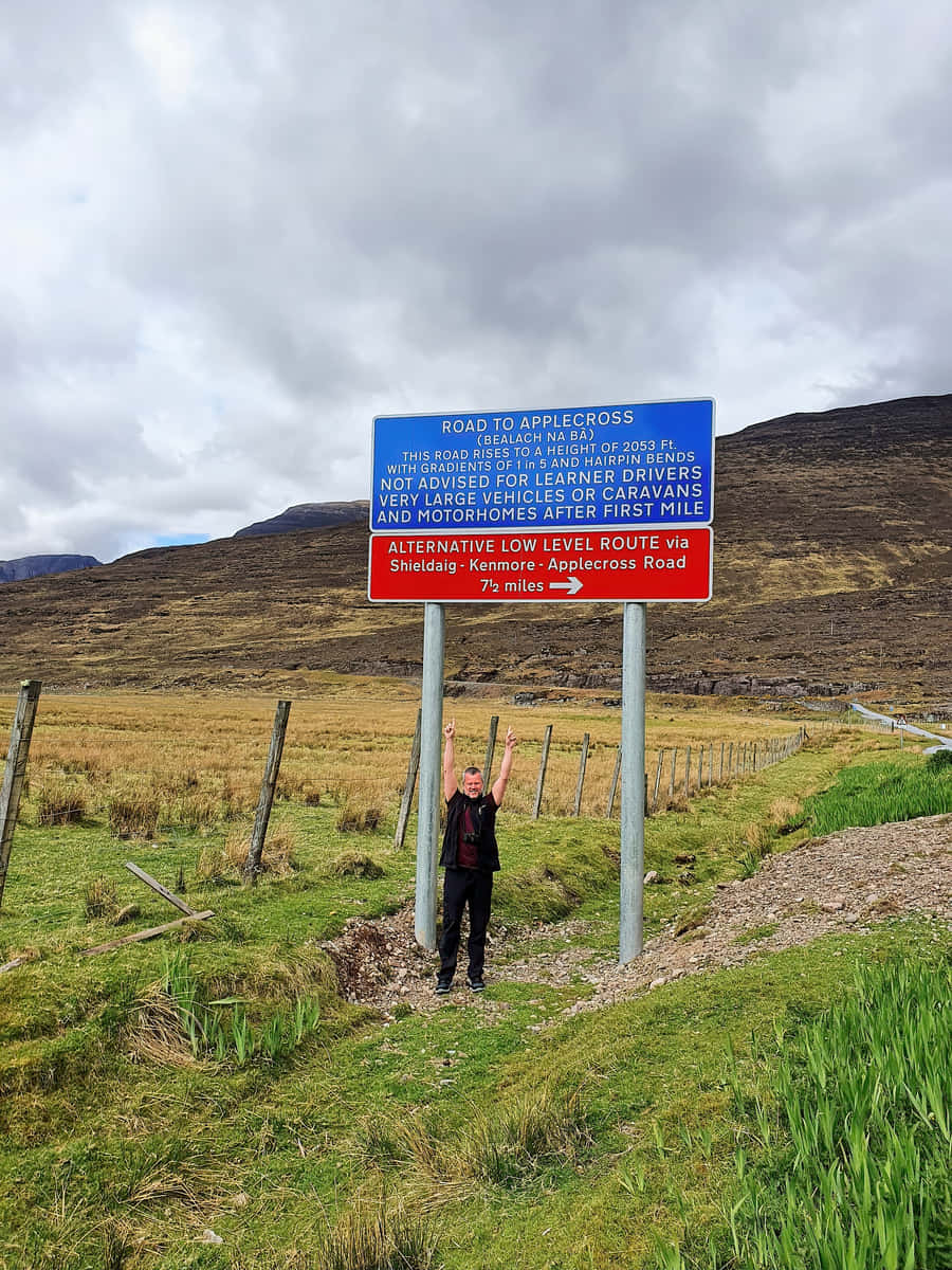
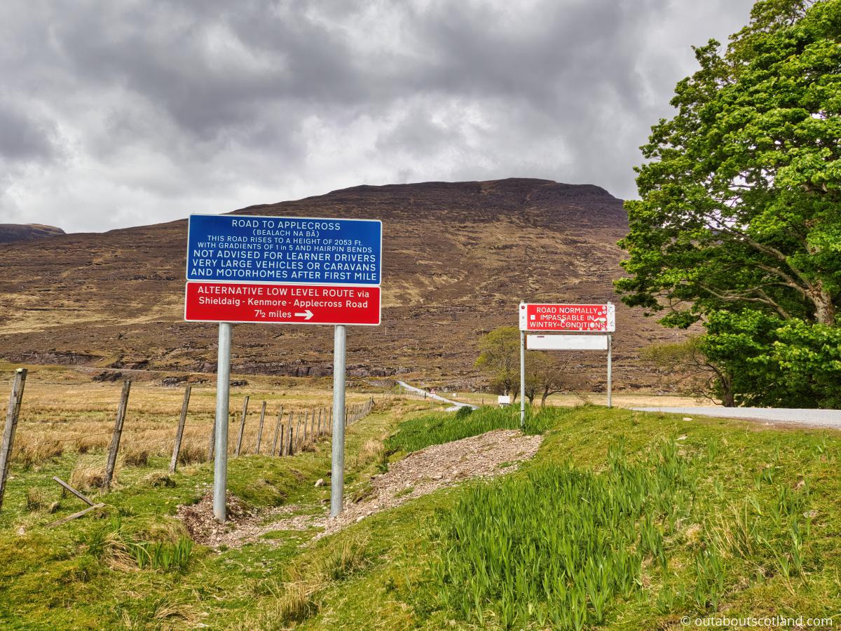
You can’t miss the start point on the A896 as it’s signposted well in advance, and there’s a café next to its junction, which is one of the few places to grab a bite to eat in the area. The road widens slightly at this point, so if you want to snap a selfie in front of the famous warning road sign, you can park up, but there’s a designated car park a little bit further on if the verge is full, which it almost always is. (This is a very popular tourist site.).
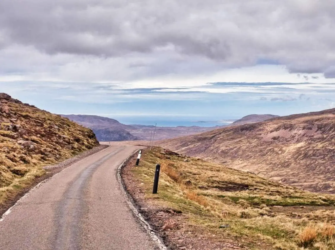
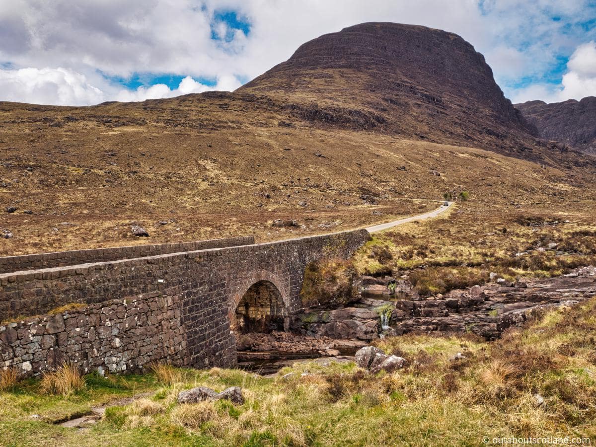
The road offers gorgeous views of Lochs Kishorn and Carron at the start before turning 90° west where it winds its way between mountains that loom overhead on either side. This is the most dramatic part of the route, and it’s extremely photogenic, so thankfully the road has been widened slightly for those drivers that are looking at the views to the sides instead of the road ahead.
What surprised me when I drove the Bealach na Ba was the number of passing places which have obviously been installed to cope with large numbers of visiting tourists. Some of these are large enough to temporarily pull into, so if you want to stop and take a few photos, keep your eyes open for these large passing spaces and pull as far in as you can.
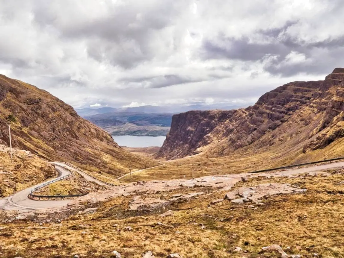
These spaces aren’t designed to leave cars unattended, so it’s handy that there are two car parks at the summit, the first of which offers a superb viewpoint for the ultra-tight hairpin turns the pass is famous for. Stopping there is an absolute must, as you’ll be able to look back down at the route you’ve just taken, which has to be up there with the best scenic views in Scotland.
The second car park lies around the corner which is the highest point of the pass and it’s another spot to take in some amazing views, only this time you’ll be able to look west towards the islands of Raasay, Skye, and Rum.
The terrain is rough moorland for miles in all directions, but if you like going off-grid, you can walk to the summit of Sgurr a Chaorachain from the top car park, which is one of the peaks that overlooks the Bealach na Ba.
It’s quite an easy route as Corbetts go as you will have already completed most of the ascent by car, just be aware the terrain is very rough from start to finish. Walk Highlands has a complete route description if you’re interested.
From the car park, the road immediately begins its descent to Applecross, which is a less inspiring landscape but still scenic in its own barren way. The gradients are much shallower as you head downhill, but there are a few more tight twists and turns, and you’ll no doubt encounter lots of other road users trying to squeeze their way past as they make their way back over the Bealach na Ba.
There’s not much to say about this western stretch of road until you reach the village of Applecross.
Applecross is known locally as ‘the street’, and to be honest, that’s all it is—a single street that follows the shoreline south of Applecross Bay. Were it not for the fame of the Bealach na Ba, this would no doubt be fairly deserted, but a few entrepreneurs have set up cafés and a couple of gift shops, and there’s a visitor centre and a pub as well.
After you’ve grabbed a coffee, my advice to top off a day on the Applecross Peninsula is to drive to the other side of the bay where you’ll find a wee community-run heritage centre and a footpath that follows the shoreline to the beach of Applecross Sands.
This 4-mile footpath features extraordinary views of the west coast islands, and it’s a great way to get some fresh air before making the return journey across the Bealach na Ba, unless you want to follow the North Coast 500 along the narrow coastal road heading north towards the A896 and Shieldaig.
Things to Do
Scenic Drive: The Bealach na Ba is well known for its incredible driving route. Wind through steep gradients, sharp bends, and stunning scenery that rivals any other landscape in the world. It’s a thrilling experience for any driver – but care must be taken on the hairpin bends and drivers should note that large vehicles are not suitable for the mountain pass.
Photography: The views from the summit of the Bealach na Ba are truly breathtaking. Capture the stunning vistas of the mountains, sea, and the Isle of Raasay in the distance. It’s a paradise for photographers, where every angle offers a new perspective.
Hiking: There are numerous walking routes around the Bealach na Ba. You can explore the rugged mountain landscape of Beinn Bhan, discover hidden waterfalls, and take a scenic walk to the Applecross Tower Station. Don’t forget to pack your walking boots. Click here to see waterproof boot reviews.
Cycling: For those seeking a challenge, cycling up the steep gradients of the Bealach na Ba is a rewarding feat, but it’s not one for the untrained cyclist. The road is hard work and there are places where the side of the road drops down into deep chams, but it’s a hugely satisfying ride nonetheless.
Wildlife Watching: The area around the Bealach na Ba is teeming with wildlife. Look out for red deer roaming across the hills and golden eagles soaring in the sky above. Just remember to take your binoculars. Click here to see binocular reviews.
Things to Do Nearby
Applecross. Strathcarron IV54 8LR. 17-minute drive.
This fishing village is located on the west coast of the Applecross Peninsula and is the finish point for the Bealach na Ba drive from the A896. The village is over 1,300 years old and caters to visitors with cafés, a pub, and a number of scenic walking routes in the area.
Applecross Heritage Centre. Strathcarron IV54 8ND. 17-minute drive.
This museum and research centre is run by local volunteers as a way to keep the unique culture of the Applecross Peninsula alive. The museum is housed in a restored 19th-century manse which houses a wide range of exhibits and historic records.
Applecross Bay to Applecross Sands footpath. Strathcarron IV54 8LR (Applecross Bay). 17-minute drive.
This popular walk starts on the northern edge of Applecross Bay near the heritage centre and finishes 4 miles (6.44 km) north at Applecross Sands. The footpath is renowned for the stunning views it offers across the water towards the Isle of Raasay.
Sgùrr a’ Chaorachain. Strathcarron IV54 8XF. 5-hour walk.
This Corbett is located to the east of the Bealach na Ba. The 8-mile return route to the summit is steep and difficult but offers intrepid hillwalkers stunning views of mountain ridges and dramatic corries. Visit Walk Highlands for a full route description.
Strome Castle, Loch Carron. Strathcarron IV54 8YJ. 40-minute drive.
Not much remains of the 14th-century Strome Castle other than a few stone walls, but it’s worth visiting for the viewpoint that looks over Loch Carron and the Inner Sound towards the Isle of Skye.
Frequently Asked Questions
How hard is the Bealach na Ba?
The Bealach na Ba climb is difficult, whether cycling or driving. The road rises 626 metres above its sea-level starting point on an incline that is 5.5 miles long.
The Bealach na Ba is 20% at its steepest gradient, has lots of switchback turns, and is single-track, making overtaking virtually impossible for cars. However, the road surface is high-quality tarmac and is in a good state of repair.
Is the Bealach na Ba one way?
The Bealach na Ba is entirely single-track but it is not one way, and access is possible from both directions of Loch Kishorn and Applecross.
Drivers meeting cars coming in the opposite direction have multiple passing places to pull into.
Is the Bealach na Ba suitable for motorhomes?
Driving the Bealach na Ba in a motorhome is not advisable. The general opinion is that vehicles no larger than a VW camper van should attempt crossing the pass due to its very tight turns.
A warning sign at the Strachcarron end says: “This road rises to a height of 2053 ft, with gradients of 1 in 5 and hairpin bends. Not advised for learner drivers, very large vehicles or caravans after first mile.”
Is the Bealach na Ba on the NC500?
The Bealach na Ba is part of the Wester-Ross section of the NC500.
How long is Bealach na Bà pass?
The distance between the Bealach na Ba start and finish points is approximately 20 miles (32 kilometres). It is the third-highest road in Scotland and is the steepest road in the UK.
How far is the Bealach na Ba from Applecross?
The Bealach na Ba viewpoint is located 5 miles (a 14-minute drive) from Applecross.