Rob Roy Way, Callander
The Rob Roy Way is an 80-mile walking and cycling route between Drymen in Stirling and Pitlochry in Perthshire. This section of the route runs through the town of Callander to the village of Strathyre on attractive paths that border rivers, lochs, steep hills, and open glens.
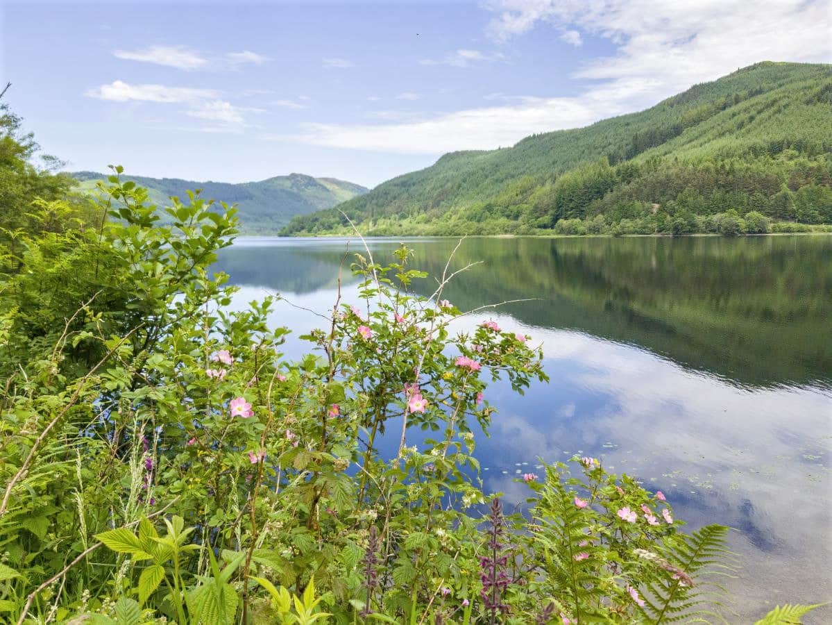
The trail is fairly flat and level, so it offers an enjoyable day out for all abilities and ages, though the more adventurous can take detours to enjoy the glassy expanse of Loch Lubnaig and the tumbling waters of the Falls of Leny before continuing on to a well-deserved drink at Lochearnhead.
🠇 Head to the bottom of the page for essential details on each attraction featured here, including addresses, opening hours, and entry prices 🠇
Rob Roy Way
Central Scotland is a real gem when it comes to regions with stunning outdoor attractions. With the Highland mountains rising up to the north and the many lochs of the Trossachs sweeping away to the west, the landscape is extraordinarily varied, to say the least.
One visitor-favourite destination that welcomes tens of thousands of tourists each year is Callander, a small Perthshire town that’s frequently referred to as ‘the gateway to the Highlands’ due to the many walking and cycling trails that join it – including the much-loved Rob Roy Way.
If you’re unfamiliar with this trail, it’s a relatively new 79-mile walking and cycling route between Drymen and Pitlochry that was created in 2001 and has already been designated as one of Scotland’s Great Trails.
The name, as I’m sure you’ve already guessed, derives from the Scottish outlaw Rob Roy MacGregor who spent most of his time in the Trossachs, where the route starts, with his final resting place located in a graveyard near Callander.
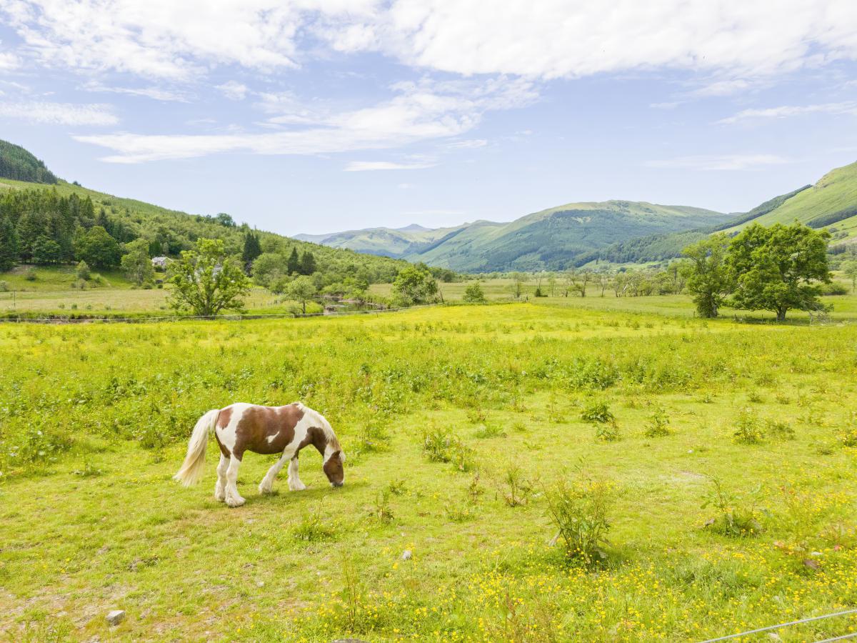
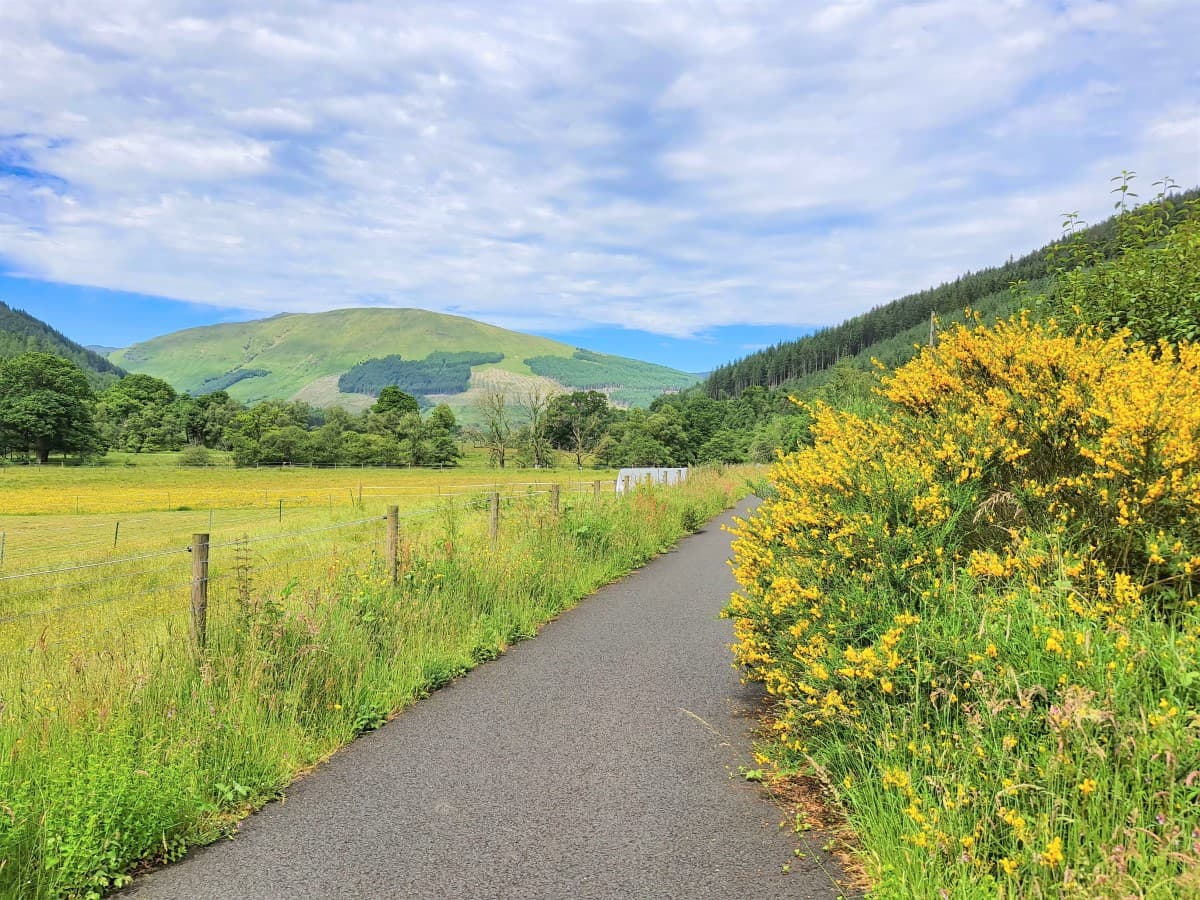
All sections of the Rob Roy Way are a pleasure to follow but the one near Callander is a personal favourite as it passes through a beautiful landscape of glens and forests surrounded by mountains and hills, interspersed by a number of exceptionally scenic lochs.
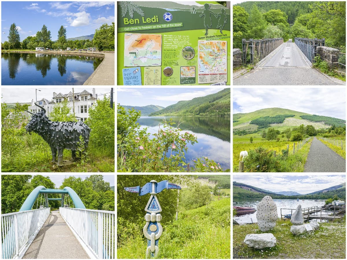
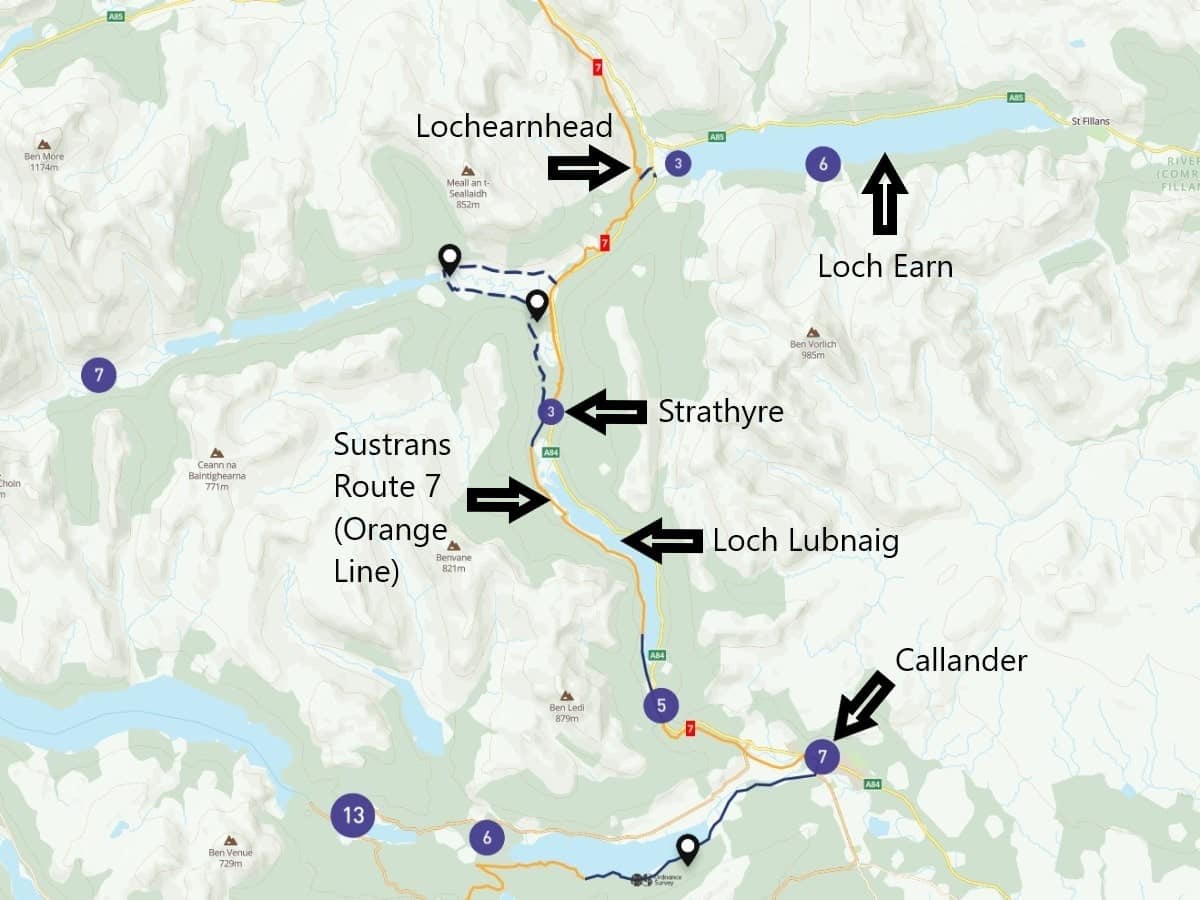
The most common direction to tackle the route is heading south to north, starting at The Meadows car park in Callander and closely following the Garbh Uisge (AKA ‘the rough water’) which flows into Loch Lubnaig. From there, the trail winds its way through a forest before ending at the attractive Highland village of Strathyre, which marks the end of Section 3, as shown on the official Rob Roy Way website.
That particular section of the trail is around 8.5 miles in length which is a decent enough trek on two feet, but if you’re travelling on two wheels you may find yourself craving more of this stunning Central Scotland countryside. In that case, I recommend continuing along the path for 4 miles to Lochearnhead, which is a small village situated on the western end of Loch Earn.
Once there you’ll be able to enjoy a coffee at one of the pubs that overlook the loch before returning on the same route back to Callander, or pushing on to complete section 4 of the Rob Roy Way which runs through the lovely Glen Ogle before finishing at Killin and the white waters of the Falls of Dochart.
The Highlights
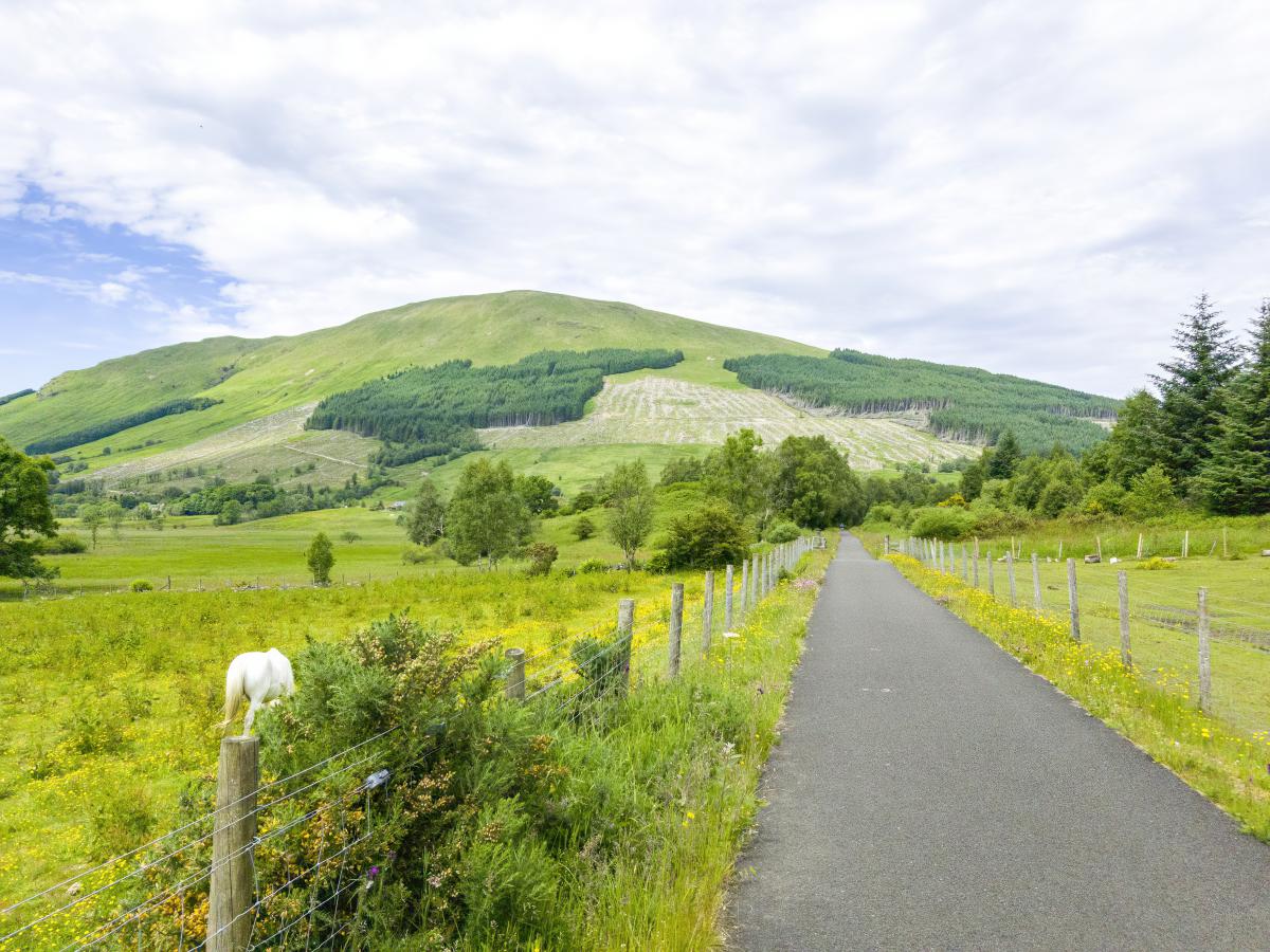
1: This is one of the best cycling routes in Central Scotland. As it’s part of the Sustrans Route 7 the path has been widened and made (mostly) level so it’s ideal for family days out, especially if you have younger children.
2: Callander is a lovely wee town so it’s worth having a look around before setting off on the trail. There are lots of independent cafes and gift shops on the high street while slightly further afield there are attractions including the Bracklinn Falls and Loch Venachar.
3: The Rob Roy Way/Sustrans Route 7 passes the start of the climb up Ben Ledi which is a superb detour for the ultra-energetic. For those who prefer more relaxed diversions, I recommend soaking up the view from the shore of nearby Loch Lubnaig, which is a popular destination for kayakers and paddleboarders.
Visiting Tips
1: This route can be completed in either direction but be aware there is no public car park in Strathyre so if you’re following the path north to south you might consider leaving the car further up the road at Lochearnhead. Heading in the opposite direction is no problem, as there are two large car parks in Callander and another car park at the foot of Ben Ledi.
2: Facilities along this route are few and far between so if you need a packed lunch your best option is heading to the Tesco Express in Callander. There’s also a cafe at the Forest Cabin Holiday Park situated next to Loch Lubnaig and there are a couple of pubs in Strathyre – but these are usually closed out of season.
Lochearnhead has a couple of small shops and a couple of pubs that serve food – the highlight of which (in my opinion) is the Clachan Cottage Hotel which has outdoor seating overlooking Loch Earn.
Tourist Information
One of the bonuses of following the path from Callander to Strathyre is that it’s part of the Sustrans National Cycle Network so you can pretty much guarantee the surface will be well-maintained along its entire length no matter the time of year.
If you haven’t checked out the Sustrans website yet I highly recommend you take a look as they manage a vast network of paths that are wide enough to accommodate both cyclists and walkers, are well signposted, and have been chosen for their level topographies that bypass the worst of Scotland’s hill climbs.
The majority of the Sustrans cycle and walking paths are entirely traffic-free, and this section of Sustrans Route #7 is no exception so it’s suitable for families – although the littlest legs may struggle up the hill at the northern end of Loch Lubnaig.
As far as offering advice on how to tackle this route, well, to be honest, there isn’t much that needs to be said. Although signs for the Rob Roy Way are slightly lacking there are plenty of Sustrans markers so anyone completing this route just needs to follow the signposts.
These are located on each junction where the cycle/footpath splits and are always blue with a list of locations, the distance from the sign to each location, and indicators as to whether the path is suitable for cyclists (picture of a bike), walkers (picture of a person walking), or both.
There will also be a red box with a white number which indicates the Sustrans route (in this case the number 7). If the number in the red box is in brackets it means you’re not on the route yet but you’re heading towards it. If the number has no brackets it means you’re already on the route.
One other point to note about Sustrans routes is that if the path has been designated for use by both walkers and cyclists, then it will be split down the middle by a white line with painted depictions of a bike or a person to indicate which side to keep to.
As a rule, walkers always have the right of way so cyclists should dismount if there’s no way to get around them, and they must also have a bell fitted to their bike as well as a set of working lights. The rules for cycling in Scotland are pretty relaxed, but if you’re not sure of the guidelines, you might like to read the Rules for Cyclists section of the UK Highway Code.
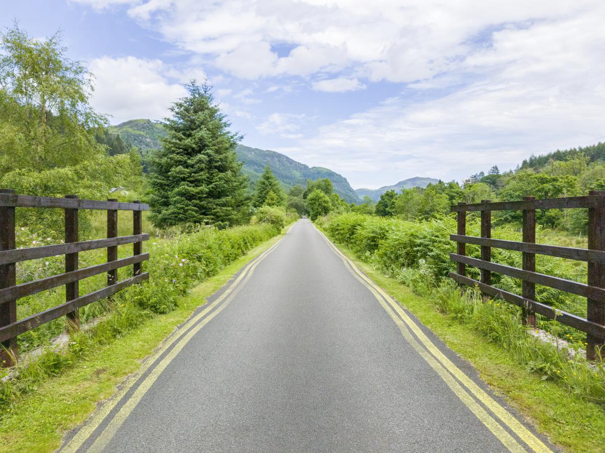
This particular section of Sustrans Route 7 is comprised of varying surfaces, starting with tarmac at Callander which transitions to gravel at various points before finishing on tarmac again at both Strathyre and Lochearnhead.
Note that there’s one section of the route where the Sustrans and Rob Roy Way diverge for 2 miles between Strathyre and Kingshouse. Both directions are worth following but for simplicity’s sake, I suggest continuing along the Sustrans Route 7 path instead of crossing the A84 and heading east into the hills at Strathyre.
However, it’s not a big deal if you follow the Rob Roy Way instead as both paths meet again near the Mhor 84 hotel which makes a good midway pit-stop to grab a coffee and use the facilities in their (excellent) cafe.
There are very few inclines along the trail so children shouldn’t have any problems bombing along in front of mums and dads, but be aware there are a couple of places where the path crosses minor roads so they’ll need to be supervised on occasion.
I’ve included a map of the Sustrans/Rob Roy Way between Callander and Lochearnhead below, but if you want a map to take with you, I recommend Ordnance Survey maps, which indicate every path in the area as well as gradients, points of interest, and dangers to be aware of.
Things to Do
Hiking on the Rob Roy Way: The trail offers a variety of terrains from quiet country lanes, rural paths and forest tracks to high moorlands. The walk is a great way to enjoy Scotland’s natural beauty far from roads and built-up areas.
Cycling: If you prefer two wheels, the Rob Roy Way is perfect for cycling. The route offers some challenging climbs but is, on the whole, relatively flat. You can enjoy the stunning views of Loch Venachar and Loch Lubnaig while cycling this part of the Rob Roy Way.
Visit Rob Roy’s Grave: A short detour from the trail will take you to Rob Roy’s final resting place in Balquhidder church cemetery. The grave is inscribed with the words ‘MacGregor Despite Them’.
Wildlife Spotting: Keep an eye out for the local wildlife. You’ll likely spot deer and a variety of bird species including buzzards and eagles. If you’re lucky, you might even catch a glimpse of the elusive red squirrel.
Picnicking at Lochearnhead: Take a break from your journey to enjoy a picnic by the shores of Loch Earn. The peaceful setting is perfect for a bite to eat on the lochside, or alternatively, there are restaurants such as the Clachan Cottage Hotel which has windows overlooking the water.
Things to Do Nearby
Ben Ledi. Address: Callander FK18 8HF. Distance: 2.6 miles from Callander.
This 2,890-foot Corbett is one of the most popular mountains to climb in the Trossachs National Park as it has a long and relatively shallow incline with paths that are gravelled and well-maintained. Views from the path leading to the summit are nothing short of spectacular, with Loch Lubnaig winding its way north to south at the foot in an easterly direction and Loch Katrine visible to the west.
The Bracklinn Falls. Address: Callander FK17 8EQ. Distance: 1.25 miles from Callander.
The Highland Boundary Fault is responsible for creating the Bracklinn Falls, a collection of waterfalls on the Keltie River. There is a circular walking trail from Callander that takes visitors through dense woodland to see the falls at a bridge that crosses the Allt a’ Choire Bhric River.
Loch Katrine. Address: Callander FK17 8HZ. Distance: 10 miles from Callander.
Loch Katrine is arguably the second most popular tourist destination in the Trossachs National Park after Loch Lomond. While Lomond sees enormous crowds throughout the year, Katrine tends to be much quieter but with equally good facilities.
The visitor centre on the southern end of the loch has a large car park with bike hire, toilets, boat cruises, and a cycleway that follows the shoreline to Stronachar on the loch’s northwest corner. There’s also a superb cafe with terraced outdoor seating overlooking the loch.
Inchmahome Priory. Address: Stirling FK8 3RB. Distance: 7 miles from Callander.
This ruined priory is located on a small island in the Lake of Menteith. Visitors must take a boat trip with Historic Environment Scotland to get to Inchmahome Island, after which they are free to explore the priory and the heavily forested island at their leisure.
Loch Lubnaig. Address: Callander FK17 8HF. Distance: 3 miles from Callander.
Loch Lubnaig is a popular water sports destination that sees visitors come from far and wide to canoe, kayak, and paddleboard across it. Access is possible from both the east and west sides, but the best location for heading out onto the water is from the car park off the A84, which has a cafe, picnic benches, and direct access to the loch.
Frequently Asked Questions
How long does it take to do the Rob Roy Way?
The Rob Roy Way is a 79-mile trail that runs through Central Scotland from Drymen to Pitlochry. The majority of people walking the route take 6-8 days to complete it.
Some sections of the route are not suitable for cyclists, but the cyclable parts can be completed in around 3 days.
How many people walk the Rob Roy Way?
Each year, an estimated 3,000 people walk individual sections of the Rob Roy Way, and an estimated 450 people complete it in its entirety.
Can you cycle the Rob Roy Way?
The majority of the Rob Roy Way is comprised of single-track gravel and tarmac paths and forest roads that are suitable for cycling. Cyclists intending to follow the Rob Roy Way should view the route on the Sustrans Route 7 which partially follows the trail but veers away between Killin and Pitlochry.
Where does the Rob Roy Way start and finish?
The Rob Roy Way Starts in Drymen and finishes in Pitlochry. The individual sections are:
1. Drymen to Aberfoyle
2. Aberfoyle to Callander
3. Callander to Strathyre
4. Strathyre to Killin
5. Killin to Ardtalnaig
6. Ardtalnaig to Aberfeldy
7. Aberfeldy to Pitlochry