Reuval, Benbecula
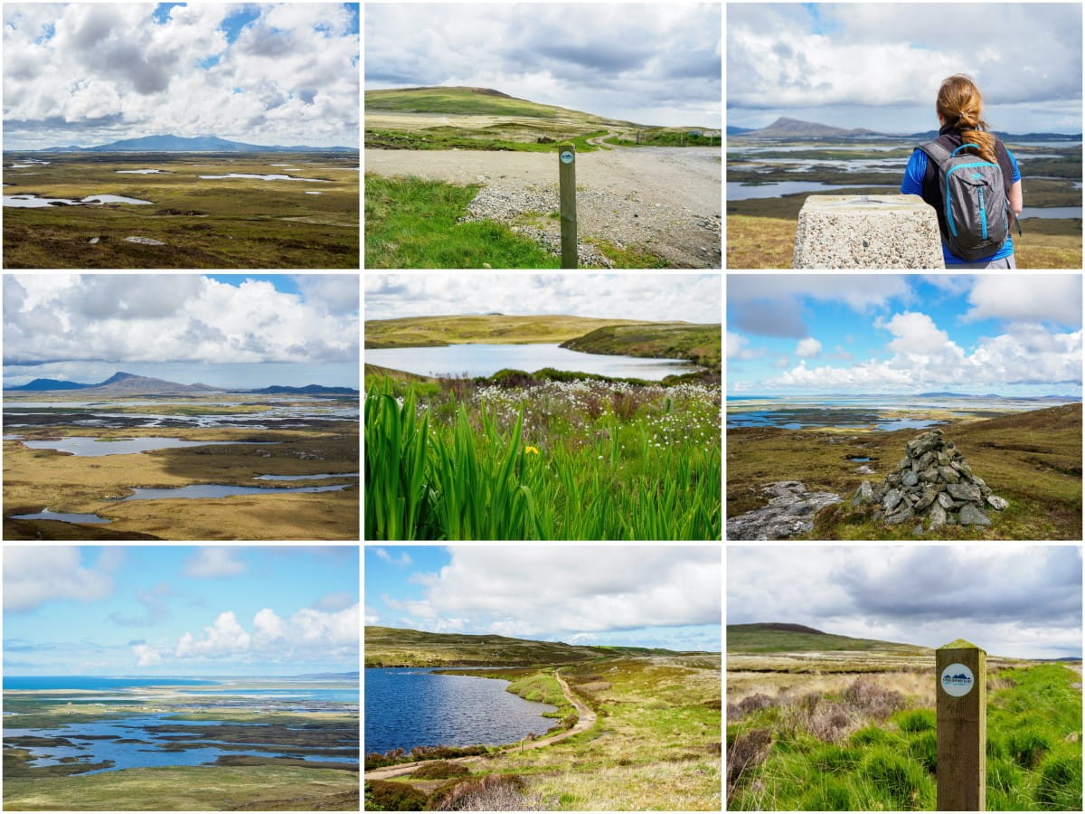
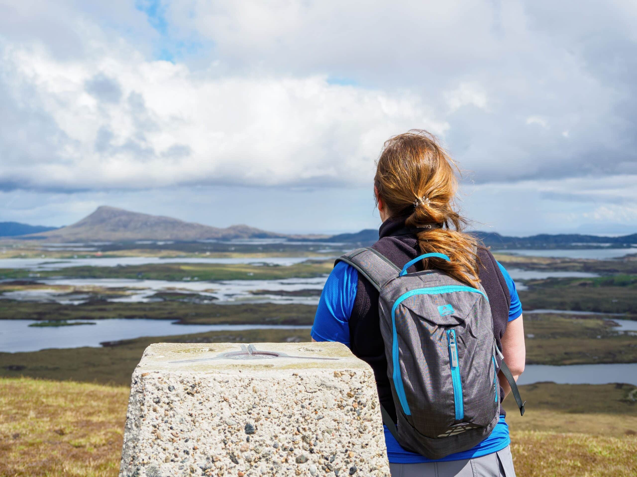
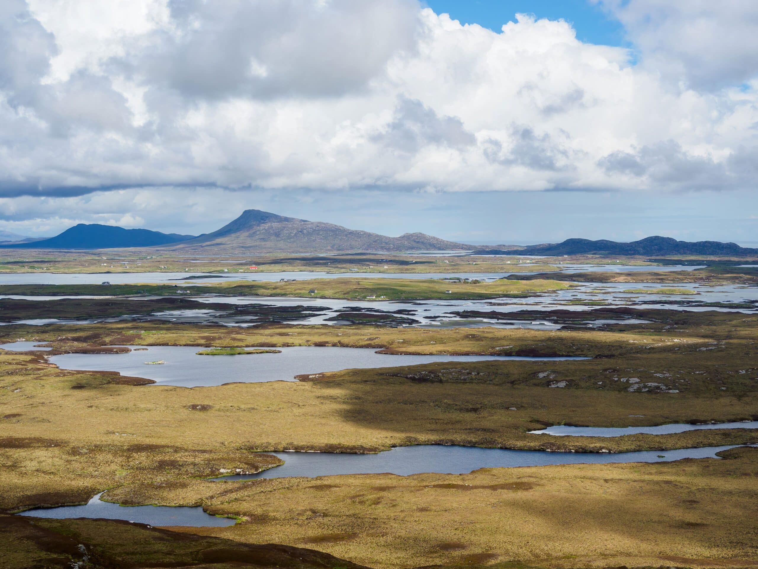
At 124 metres, the summit of Reuval is the highest point on the Outer-Hebridean island of Benbecula. Though the walk up the hill is short, it’s undeniably one of the highlights of a visit to this remarkable island, as the top offers gorgeous panoramic views of the Uists and their rugged coastlines.
🠇 Head to the bottom of the page for essential details on each attraction featured here, including addresses, opening hours, and entry prices 🠇
Reuval
The isle of Benbecula is, in my opinion, the most scenic island of the entire Outer Hebrides. While Lewis is known for its historic sites (the Callanish Stones and Gearrannan Blackhouses to name two) and the Uists are known for their pristine beaches, Benbecula is highly regarded for its beautiful landscape, where picture-perfect lochans pockmark a sweeping vista of heather and machair.
To the east are a number of white-sand beaches, and to the west is a rugged coastline that’s broken into what seems like a thousand tiny islets, while the middle of the island is home to its highest point, Reuval.
There are certainly taller and more challenging peaks to climb, but you’ll have a hard time finding viewpoints like the one at the top of this 400-foot hill.
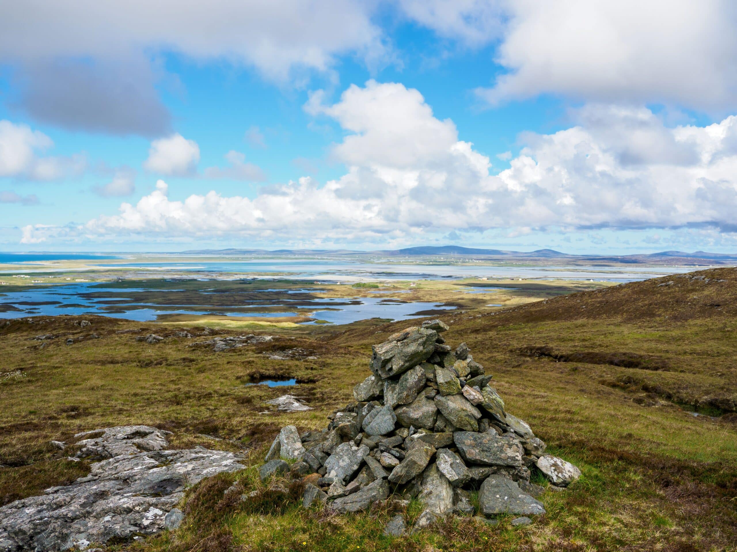
It doesn’t take long to climb Reuval, so it’s ideal for anyone looking for something to do on an afternoon in Benbecula, and its gentle ascent means it’s an easy climb for pretty much every fitness level. As soon as you get midway up the hill, the landscape of Benbecula really opens up and you’re presented with a vista of countless bodies of water in all directions.
Look east and you’ll see the peninsula of Neist Point on Skye, to the south lies the mountains of South Uist, to the west you can just about make out the Isles of St. Kilda, and to the north is the causeway joining Benbecula to North Uist as it crosses the spectacular North Ford.
If the views make you want to explore more of Benbecula, I recommend heading back to the track at the bottom of the hill and continuing along it to the east coast. In addition to the mesmerising scenery, this part of the island is notable for being the point where Bonnie Prince Charlie set off for Skye after the doomed Battle of Culloden, and it’s also a good spot for bird watching.
The Highlights
1: The views from the top of Reuval are absolutely stunning. In fact, having spent 3 weeks on a tour of the Outer Hebrides I would have to say that Reuval is one of my favourite places on the entire island chain.
2: If you’ve never seen St. Kilda before you’ll have as good a view as anywhere from the summit of Reuval. It’s a wee bit tricky to find the archipelago so a pair of binoculars and Google Maps will help no end.
Visiting Tips
1: Parking is very limited at the waste station and the narrow single-track road isn’t really suitable for pulling onto the verge. If you arrive and find the parking spaces are taken, you may have to postpone your climb. That being said, SUVs and 4x4s might be able to pull onto the grass verge at the junction of the A865.
2: Reuval is covered in thick heather and spongy moss which retain huge amounts of water. Waterproof walking boots (my recommended boots) will come in very handy on the lower part of the hill.
3: The track that runs alongside Reuval continues east for 3 miles to the coastline. Having walked a good 2/3 of it I can confirm the scenery is outstanding. My advice is to get an OS Map to help you find it.
Tourist Information
The start of the hike up Reuval begins at the least attractive part of the island, at the Market Stance waste management centre (postcode HS7 5LA). There’s a junction next to the refuse plant, which is signposted ‘Reuval Footpath’ so follow the single-track road till you get to a small parking area. If you have a camper van, you might want to give this one a miss as the spaces are tiny and it’s just about possible to fit 4-5 cars in it.
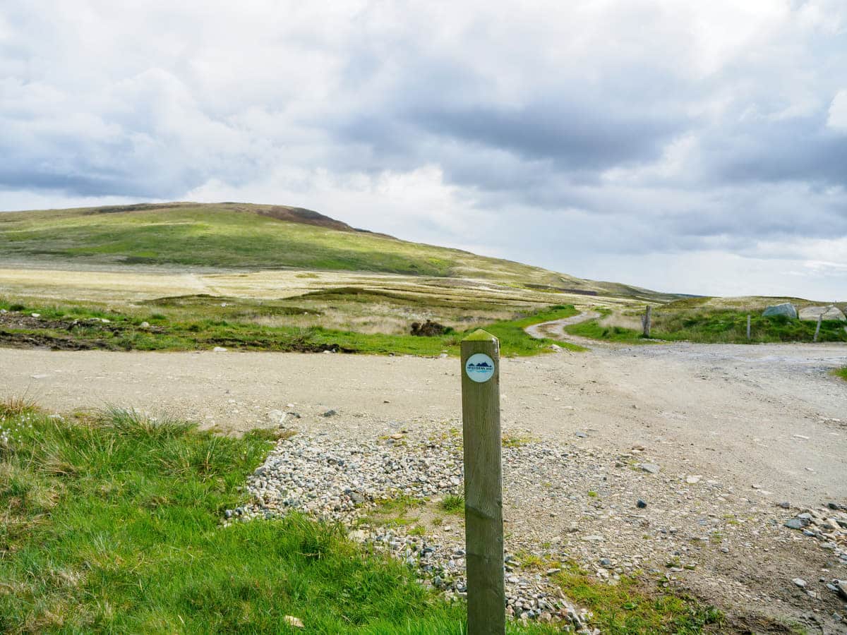
A stony track heads off in the direction of the hill, so follow it till you approach Loch Ba Una. From there, keep your eyes open for a track that heads up the slopes to the left, near an area where peat has been cut. This section of the path is rather muddy at the bottom, but it soon dries as the heather becomes thicker midway up.
The route is waymarked with a number of posts, so it’s impossible to lose track of which way to go, so continue upwards till you reach the summit, which is marked with a triangular point and a cairn. Bear in mind that there is absolutely no protection from the wind on Reuval, and the Atlantic blows in some stiff breezes, so packing a jacket is a good idea even in the height of summer.
Once at the top you might like to sit with a picnic and gaze at the sublime view before making your descent back to the car, which is as simple as returning on the same route you went up on. The entire there-and-back walk is around 2 miles, and at a gentle pace, it shouldn’t take more than two hours to complete, including photo stops and a cheese and pickle sandwich break.
Things to Do
Bird Watching: The summit of Reuval is heaven for bird watchers. Looking across Benbecula there’s a good chance of spotting hen harriers, merlins and short-eared owls as well as resident buzzards and kestrels. Bring your binoculars (link to binocular reviews), a picnic, and watch the island’s wildlife for hours on end.
Climb Reuval Hill: Reuval is the highest point on Benbecula and climbing it is a great way to experience the stunning landscape which is pockmarked with hundreds of lochans in all directions. A rough track heads to the summit which is muddy but is well-used and therefore easy to follow.
Explore Benbecula: The track leading from the A865 to Reuval Hill continues east across the island to finish in a remote area that’s pockmarked with dozens of lochans and features superb views of Benbecula’s rugged coastline. The track is flat and firm, so it is suitable for all abilities.
Cycle the Hebridean Way: The Hebridean Way follows the coastline on the B892 but you can start at the A865 near Reuval, continue north or south, and then cycle around the west coast of the island before heading back to back to your starting point. It’s a fantastic cycle route and one that I thoroughly recommend.
Spot St. Kilda: Britain’s remotest islands are normally very difficult to see, but if you climb Reuval on a clear day with binoculars, you should have a good view of the island chain by looking towards the west.
Things to Do Nearby
North Ford Causeway. Address: A865, Isle of North Uist. A scenic viewpoint on the road between North Uist and Benbecula. The causeway is part of the stunning Hebridean Way touring route.
North Uist Distillery. Address: Baile nan Cailleach, Steadings Benbecula HS7 5LU. A Gin distillery that’s located within the buildings of a traditional steading. North Uist Distillery features a gift shop and tasting sessions.
Liniclate Beach. Address: Liniclate, Isle Of Benbecula, Outer Hebrides, HS7 5PJ. Liniclate Beach is a long strip of golden sand on the southern edge of Benbecula.
The beach is a haven for wildlife and especially birds which include plover, redshank, oystercatcher, lapwing, and the elusive corncrake.
Culla Bay Beach. Address: Nunton, Isle Of Benbecula, Outer Hebrides, HS7 5LU. Culla Bay is a popular beach on Benbecula as it is set slightly inland and is therefore somewhat protected from the sea.
The bay is another highly-rated birdwatching location though it’s rather difficult to find. The best option is to head to the village of Aird which is accessed from the B892 1/2 mile south of Balivanich.
Lionacleit Sports Centre. Address: Liniclate, Isle of Benbecula, Outer Hebrides, HS7 5PJ. This is one of the few sports facilities in the Outer Hebrides. Lionacleit Sports Centre has a fully-equipped fitness suite, a 25-metre swimming pool, a games hall, and a cafe.
Frequently Asked Questions
What is the main town on Benbecula?
The main village on the Isle of Benbecula is Balivanich. It is the main administrative centre on the island and its facilities include an airport, supermarket, post office, hospital, shops and cafes. The population comprises approximately 600 permanent residents.
Where is Benbecula in Scotland?
Benbecula is an island in the Outer Hebrides on the west coast of Scotland. The island is located between North and South Uist.
Is Benbecula inhabited?
Benbecula has a permanent resident population of around 1,200 people. The majority of the island’s population works in the industries of farming, fishing, and tourism. At 31 square miles in total landmass, Benbecula is home to just 41 people per square mile.
How high is Reuval on Benbecula?
Reuval hill on Benbecula is 124 metres (407 feet) at its summit. The hill is the highest point on the island.